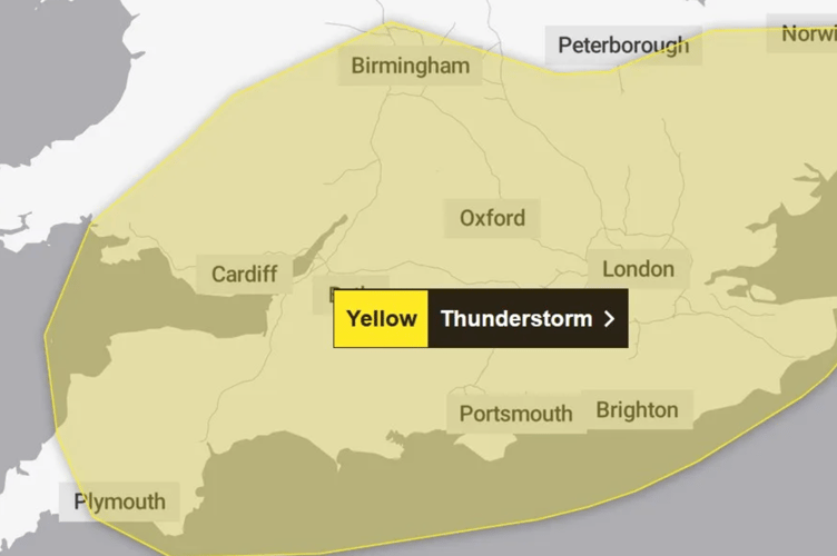
The UK’s Met Office has issued a Yellow Thunderstorm Warning for Gloucestershire. The warning, set to last from 10:00 to 21:00 on Thursday, August 7, 2025, has caught the attention of both locals and travelers. This warning indicates that severe thunderstorms are expected, bringing the possibility of intense rain, hail, and frequent lightning. With the storm impacting several regions, including London and the South East, it’s important to understand the risks involved, how to prepare, and the best ways to stay safe.

In this article, we will break down what you need to know about the warning, provide practical advice, and offer step-by-step guidance on how to stay safe. Whether you’re a resident of Gloucestershire or just passing through, this comprehensive guide will help you stay informed, prepared, and protected from the upcoming storms.
Yellow Thunderstorm Warning Issued for Gloucestershire
| Event | Details |
|---|---|
| Warning Type | Yellow Thunderstorm Warning |
| Affected Areas | Gloucestershire, London, South East, South West, and East of England |
| Warning Period | 10:00 to 21:00 on Thursday, August 7, 2025 |
| Expected Weather | Heavy rain (up to 60mm in two hours), hail, lightning, flash floods |
| Travel Disruptions | Possible delays on roads and public transport, hazardous driving conditions |
| Safety Tips | Avoid driving through flooded roads, secure outdoor items, stay informed through official updates |
In conclusion, while the Yellow Thunderstorm Warning for Gloucestershire is a serious weather event, taking the right precautions can help you stay safe. Monitor weather updates, prepare your home for potential flooding, and stay informed. Follow safety guidelines, and be ready for the storm’s impact. Stay indoors and secure outdoor items to minimize the risks posed by the storm.
What to Expect from the Yellow Thunderstorm Warning
Thunderstorms are a common occurrence in the UK, but when a Yellow Thunderstorm Warning is issued, it means conditions could escalate into something more severe. These warnings highlight the potential for storms that can bring extreme rainfall, damaging winds, and lightning strikes. In Gloucestershire, the warning indicates that from 10:00 to 21:00, thunderstorms will produce up to 60mm of rain in just two hours, which could lead to flash floods, especially in urban areas with poor drainage or near rivers.

Why You Should Pay Attention
You might wonder, “Why should I be worried about a thunderstorm?” While thunderstorms may seem like a routine weather event, the risks can be significant. Flash floods are one of the leading dangers, especially in areas like Gloucester city center where water may accumulate quickly due to overwhelmed drainage systems. Intense rainfall can also lead to hazardous driving conditions, where roads can become slick or even submerged. Lightning, while not as frequent as rain, can cause fires, damage electrical systems, and injure people who are caught outside.
Understanding Weather Warnings: Yellow vs. Amber
It’s helpful to know the difference between the different Met Office warnings so you can react appropriately.
| Feature | Yellow Warning (Gloucestershire) | Amber Warning (More Severe) |
| Impact Level | Low-level impacts, some disruption possible. | Increased likelihood of impacts, potential for significant disruption and risk to life/property. |
| Action | Be Aware, plan ahead for possible travel delays or disruption to daily activities. Keep an eye on updates. | Be Prepared, change plans, and actively protect yourself, family, and property. |
| Travel | Many can continue, but some disruption likely. Consider if you could be affected. | Increased likelihood of travel delays, road/rail closures. Avoid non-essential travel. |
| Risk | Low risk to life/property, primarily focused on minor disruption. | Increased potential for risk to life and property due to severe weather. |
Step-by-Step Guide to Staying Safe
Step 1: Monitor Local Weather Alerts
Keeping track of local weather updates is the first step to staying prepared. Follow the Met Office, download weather apps, or tune into local radio stations for the latest storm updates. These resources will provide you with timely information on the storm’s progress, including areas of highest risk and specific warnings for flooding or road closures.
Step 2: Prepare for Flooding
Flash floods can occur quickly, so it’s important to be prepared. Even if your area doesn’t normally flood, an unexpected downpour can overwhelm drainage systems. If you live in a flood-prone area, follow these steps:
- Clear gutters and drainage systems to ensure water can flow freely.
- Move any valuables off the floor or away from windows that might get broken by water.
- Use sandbags to block potential water entry points if advised to do so by local authorities.
Step 3: Avoid Travel if Possible
The safest thing to do during a thunderstorm is stay off the roads. Flooded roads, downed trees, and poor visibility can make driving dangerous. However, if you absolutely need to travel:
- Use headlights during daylight hours to increase visibility.
- Drive slowly and leave plenty of space between you and other vehicles.
- Avoid flooded areas and follow local authority updates for detours and road closures.
Step 4: Secure Outdoor Items
Storms can bring high winds, which can turn everyday items into hazardous debris. Trampolines, lawn furniture, and bicycles can be blown away, causing damage to your property or someone else’s. Bring items inside if possible, or make sure they are properly secured.
Step 5: Prepare an Emergency Kit
Power outages and disruptions are common during severe storms, so being ready with an emergency kit is a smart move. Here’s what you should include:
- Batteries, flashlights, and candles
- Non-perishable food and water (for at least 72 hours)
- Portable phone charger
- First aid kit
- Warm clothing (especially if the temperature drops unexpectedly)
Step 6: Stay Indoors During the Storm
Once the storm hits, it’s best to stay indoors. Don’t use electrical appliances or landline phones while the storm is active. If lightning is near, take shelter away from windows and doors. Stay tuned to weather updates, and wait until the storm passes before venturing outside.
Risks and Impact of the Yellow Thunderstorm Warning
1. Flooding
The most pressing risk of this storm is flash flooding. While Gloucestershire may not be a hotspot for constant flooding, this kind of sudden downpour can overwhelm systems that aren’t prepared for heavy rainfall. Areas like Gloucester City Centre and riverside locations are especially vulnerable.
2. Driving Hazards
Rain and flooding reduce visibility on the roads, making travel dangerous. Hydroplaning—when your tires lose traction on wet roads—can cause you to lose control of your vehicle. Flash floods can submerge roadways, making it impossible to see the full extent of danger until it’s too late.
3. Lightning and Hail
Thunderstorms often bring lightning and hail, which can cause serious injuries and property damage. Lightning can strike tall structures, start fires, or knock out electrical systems. Hail can damage vehicles, roofs, and even crops, leading to costly repairs.
Personal Experience: Lessons from a Past Storm
In 2018, Gloucestershire saw a similar storm, and Emma Richardson, a local resident, shared her experience. “I remember the rain started coming down so heavily that I couldn’t even see the road in front of me,” she says. “By the time I got home, the yard was flooded, and the garage doors were leaking. It was scary, but knowing how to prepare helped me stay calm.”
Emma’s story highlights the importance of staying prepared—having an emergency kit, securing property, and, most importantly, staying updated on weather alerts.
Expert Insight: The Science Behind the Storm
To further understand the severity of the upcoming storm, we reached out to Dr. Sarah Knight, a meteorologist at the UK Met Office. “When warm, moist air rises and meets cooler air at higher altitudes, thunderstorms develop. The danger increases when there’s a lot of moisture, which can lead to torrential rain,” she explains. “The Yellow Warning is issued because we know the conditions are ripe for severe weather, but we also want to give people enough time to prepare.”
FAQs
What is a Yellow Thunderstorm Warning?
A Yellow Thunderstorm Warning indicates that thunderstorms are likely, but not necessarily severe. The storm may bring heavy rain, lightning, hail, and flooding, but widespread disruption is not expected.
How can I stay safe during the storm?
To stay safe, monitor local weather updates, avoid traveling, secure outdoor items, and stay indoors during the storm. If possible, prepare an emergency kit with essentials like food, water, and flashlights.
How can I prepare my home for flash floods?
To prepare for flooding, clear gutters and drains, secure valuables, and use sandbags to prevent water from entering your home. Consider installing flood barriers in flood-prone areas.


